There’s a ton of work that goes into one of these trips so between the three of us we’re just about ready. The below gets into the planning. We compiled a ton of data to hopefully make the correct decisions as time goes on.
Possible Travel Schedule, Projected Weather Patterns for Each Calendar Day, Plus Elevation Changes
Day 0: Thursday, Sep 19th:
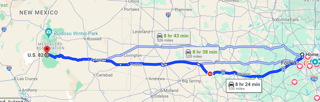
Jeff and Ron leave the Dallas/Ft Worth area at 9 a.m. to head 8.5 hours to Cloudcroft. I’m flying into El Paso and my friend Matt will pick me up at the airport. He just happens to live on Section 2 of the NMBDR so that’s helpful. I’ll stay at his place Thursday night and then head to Jeff/Ron’s Airbnb about ten miles down the road Friday night.
Day 0: Friday, Sep 20th:
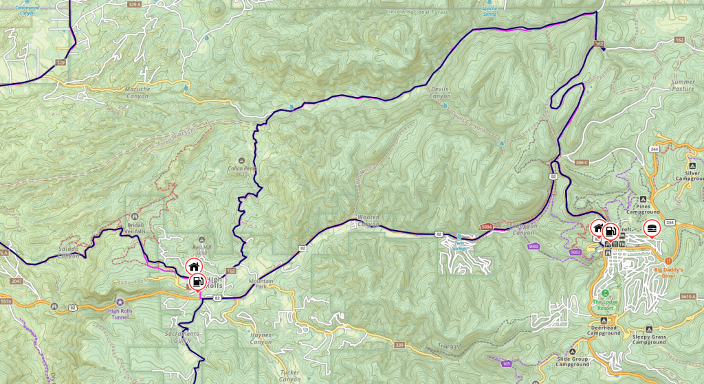
Jeff and Ron will get up early and try to jet the carb on the KTM. No idea how the bike will react until at altitude with the correct jet. Two of the three bikes have fuel injection, but Jeff decided to go old school and bring a carb. Once the new jet has been installed all three of us will load all the gear, suit up and cruise around at elevation to make sure the bikes are acting right. Dinner will be at the Cloudcroft Brewing company.
Day 1: Saturday, Sep 21st: The Official Start
We will travel from Matt’s house in High Rolls, NM. We will get up early in the morning, ride over to Cloudcroft, have breakfast, and jump on the MBDR, ending in Carrizozo. Section 2 is 171 miles. Gas options are plenty. Once we fill up in Cloudcroft, we will not have a problem making it to Carrizozo. Gas and lunch in Ruidoso. Fill up before the hotel in Carrizozo.

Lunch in Ruidoso
https://www.yelp.com/biz/downshift-brewing-co-riverside-ruidoso
Downshift Brewing Company
Dinner Carrizozo restautant
Roseys Pizza
https://www.yelp.com/biz/roseys-pizza-carrizozo-2
******There is a bike shop in Carrizozo if needed.
Day 2, Sunday, Sep 22nd
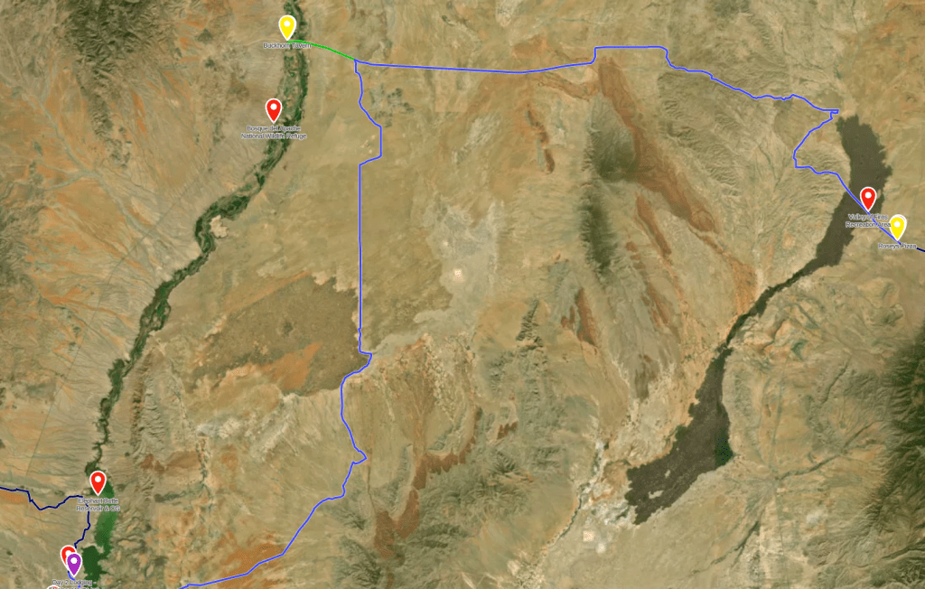
Section 3: Carrizozo to Elephant Butte
San Antonio restaurants:
Lunch – Buckhorn Tavern, off BDR lunch/gas stop
https://www.buckhornburgers.com/
Elephant Butte
(Truth or Consequences Brewing Company) Dinner
10 minute ride from the hotel
410 N Broadway St
Truth or Consequences, NM, 87901
575-297-0289
Day 3, Monday, Sep 23rd: Elephant Butte to Reserve, Stop at Winston Food and Gas General store for lunch/gas

Lunch, only option Winston Food and gas, right before Chloride Canyon, choose either the red route or the easy route, choose wisely. Kevin votes red!!
Only descent food looks to be Adobe Café and Bakery for dinner, they will be closed on Tuesday morning, so it might be a possible dinner spot. It’s about 12 minutes from the hotel on the BDR. Will require a little backtracking.
http://www.theadobecafeandbakery.com/
2134 US-180, Reserve, NM 87830
Winston General Store (no choice) Lunch
Marked on the map already
Right before the Chloride Canyon
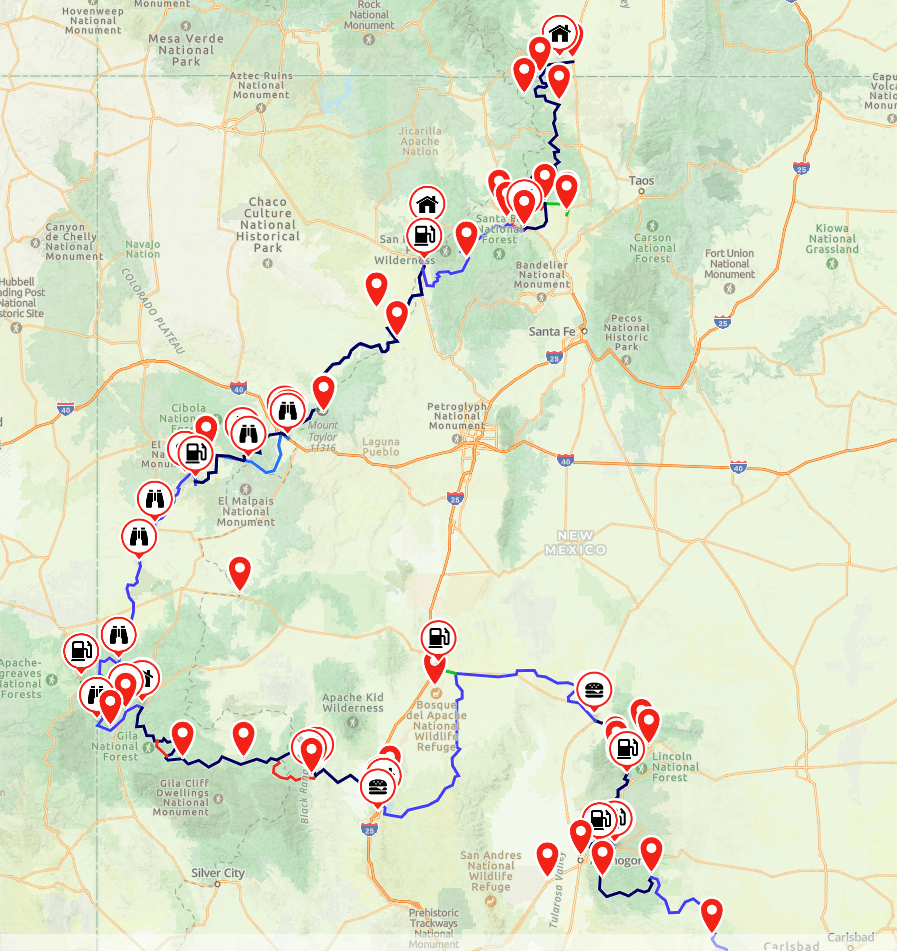
Day 4: Tuesday, Sep 24th – Reserve to Grants (Long Day)

Reserve food looks sketch, might be a rough day for food stock up at the gas station when leaving reserve. All restaurants around are closed on Tuesdays, even the ones in Alpine.
Early dinner look like the Candy Kitchen maybe, its marked on the map. Freeze dried meal? Pinehill has food and gas.
Suggest taking the blacktop into Grants and skipping the dirt at around the 10 hour mark, we will see when we get to Pinehill how we are for stamina. Alternate route in in Gaia. Kevin votes trail! Total mileage for this day will be well over 200 miles.
Day 5, Wednesday, Sep 25th – Grants to Cuba
Days Inn to the Air B&B in Cuba is looking tough for lunch.
Grab breakfast in the morning in Grants, and maybe eat a dehydrated meal for lunch or grab something at the gas station in Grants to snack on. Gas up, there is one stop way off the trail. Total mileage is 136 miles, doesn’t look like a tough day, just desolate. Eat in Cuba, or grab stuff to cook at the Air B&B.
Driving through Cuba NM – YouTube Link
Day 6: Thursday, Sep 26th – Regina Air B&B (Cuba) to Abiquiu
Sticking with the NMBDR route from Cuba to Abiqui. Looks like its about an 80 mile ride. When the route ends, load up the Abiqui to Air B&B route in Gaia. Fill up in town before heading to the Air B&B. Apparently the road after the dam around a blind corner is washed out, DANGER.
Day 7: Friday, Sep 27th – Abiuqui to Antonito Colorado
Last day, 122 miles bring it on home. Airbnb – cabin
Day 8: Saturday, Sep 28th – Antonito, CO
I’m taking the highway back to High Rolls, NM to Matt’s house. Should take about 6 hours. If I leave early enough I should get there for a late lunch and relax the rest of the day and pack up. Jeff/Ron will load the bikes in a prepositioned truck and head back to Ft Worth/Dallas.
Day 9: Sunday, Sep 29th
Fly from El Paso to Madison, WI and land at 9:30 p.m.
Random Information about the NMBDR
TRAVEL INFORMATION
Accommodations
Like the IDBDR, the NMBDR has a scarcity of hotel opportunities along the route. Camping on the other hand is plentiful. Official campgrounds are shown on the front of Butler Maps NMBDR paper map with a small tent icon and many more primitive backcountry camps can be found along the way. Because of the limited beds available in the small towns along the NMBDR, it is recommended that riders make reservations ahead of their arrival. Rooms can be found in Cloudcroft, Ruidoso, Carrizozo, Truth or Consequences, Reserve, Grants, Cuba, Abiquiu`, and Antonito, CO. Additional off-route lodging opportunities available in Socorro and Ojo Caliente.
Navigation Resources
Be Prepared!*Bring the Butler Maps NMBDR paper map along with your REVER routes. You can upload these tracks onto your GPS device or download them to your REVER app to use offline. A full-length documentary of the scouting expedition is available on the Touratech-USA*website*as well as the Butler Maps*site. Since cell phone coverage is limited on much of the route, satellite communication devices are a great idea for unexpected emergencies and it is recommended that routes are downloaded onto REVER’s Offline feature as back-up.
Fuel
Don’t get stuck in the backcountry with an empty tank. The longest distance between fuel stops on the NMBDR is just over 153 miles. Even if your bike can go well beyond this distance, we recommend carrying extra fuel.
When to Go
Many of the higher elevation sections of the NMBDR are not passable in winter months. The ideal time to ride the entire route is June through October.
Section 2 (including route # 4 & 5) ‘Ruidoso to Truth or Consequences’
Section 2 begins with a series of rock-based, mountain roads. You’ll twist and turn through high-elevation deciduous forest and across numerous slow-moving streams enroute to Ruidoso, an engaging mountain hamlet. The route continues north of town on its timbered trek before dropping into the Tularosa Valley and onward to the Town of Carrizozo. If you’ve been experiencing bike issues, the ‘Carrizozo Bike Shop’ has an extensive knowledge of European and other metric-spec bikes. Not long after a short jaunt on US Highway 380, the pavement changes to dirt and begins to turn north by way of a spectacular double-track. Take it ALL in, this is New Mexico at it’s nest! Please note: there are private ranches in the area – a safe and respectful speed is imperative to avoid losing the privilege of riding such a remarkable section. Regain the highway about 35 miles down the road and head west and then south toward the White Sands Missile Range. This lengthy, quite sandy passage is appropriately named ‘Jornada del Muerto’ (Route of the Deadman) as there are no amenities for the next 105 miles!
Highlights: Ruidoso is a cool resort town – Bonito Lake – Nogal Canyon Road – Main Street burro art in Carrizozo – Valley of Fires Recreation Area
Heads Up
Alert: Very few services – Working ranch north of Carrizozo, watch for cattle – CR A153 and A250 are sandy and can be deep at times
Camping: Bonito Lake – Primitive camping along NF 108, CR 176 – Campgrounds outside of Ruidoso and Carrizozo
Fuel + Food: Ruidoso – Carrizozo – Truth or Consequences
Hotel + Motel: Ruidoso has several – Carrizozo has one but not always open – Truth or Consequences has many small boutique motels with hot springs
Section 3 (including route #’s 6 & 7) ‘Truth or Consequences to Reserve’
Launch this section in Truth or Consequences, a town that got its moniker from a popular 1950’s game show. Don’t miss out on the many thermal pools that T or C offers – it’s the best way to soak away the aches and pains from a long day in the saddle! The route moves north along the banks of Elephant Butte Lake, which boasts some of the most spectacular camping along the entire NMBDR. After bisecting I-25, the road climbs up and into the Sierra Cuchillo foothills of the Black Range and on toward Winston. Stock up on fuel and supplies at the General Store and get ready for Chloride Canyon, a protracted technical section (you’ll cross Chloride Creek over 100 times in this section), before riding up and over the divide to Reserve. This is arguably the most remote part of the NMBDR: if you aren’t a confident and skilled rider, we recommend skirting this section and hitting the pavement for 30 miles instead of riding the dirt. The following 100 miles escort riders through high-elevation woodland, breathtaking scenery, and fast rhythmic double-track. Pristine freshwater lakes accent the entire journey – pick a pool and take a quick, invigorating dip to clear your head for the rest of the trip.
Highlights: Hot Springs in T or C – Camping on Elephant Butte Lake – Winston General Store – Chloride Canyon – Gila National Forest – Snow Lake
Heads Up
Alert: Only regular fuel in Winston – Chloride Canyon is prone to flash floods – Chloride Canyon is an ‘Intermediate Plus’ route. An alternative easier route is available – Routes can be impassable if wet west of Winston
Camping: Dispersed/Organized at Elephant Butte Lake – Many camping opportunities in Gila National Forest west of Winston
Fuel + Food: Truth or Consequences – Elephant Butte – Reserve
Hotel + Motel: T or C has many small boutique motels with hot springs as well as larger chain options for lodging – Winston General Store has one cabin – Reserve has on 8-room motel with hot springs
Section 4 (including route #’s 8 & 9) ‘Reserve to Fence Lake’
As is common along the NMBDR gas stations are sparse, so don’t forget to top off while in Reserve – the small service station in Luna is often closed. This route parallels Arizona, all it takes is a quick ride 500 feet down a fork to hit the state line. You’ll pass scads of Piñon and Juniper and catch glimpses of ancient cliff dwellings high along the cliffs. By and by, the track drops down into a high desert and then heads due north to US Highway 60 and the Zuni Reservation. An overlook near the Zuni Salt Lake showcases just how desolate and otherworldly this area truly is. There’s a wild and terrible beauty in western New Mexico unlike any other state in the Union.
Highlights: High elevation road out of Reserve – Ride into Arizona on this trip – Fun flowing forest roads – Wild horses – Zuni Salt Lake Overlook
Heads Up
Alert: Road west out of Reserve can be impassable when wet – Fuel store in Luna isn’t always open – Travel slow through ranch north of Highway 60 – No services in Fence Lake
Camping: Dispersed/organized in the Gila National Forest – Some camping on BLM north of Highway 60 – Nice private campground north of Reserve with showers and laundry
Fuel + Food: Fuel and a great little grocery store in Reserve – Luna (not always open)
Hotel + Motel: Reserve has one 8-room motel – Reservations are suggested
Section 5 (including route #10) ‘Fence Lake to Grants’
Viable camping spots are scarce along this leg of the NMBDR – any camping here must be viewed as a privilege and access is granted solely by the residents of the reservation. However, easily accessible camping is found just south of Grants inside the Cibola National Forest farther down the road. Wide open spaces and picturesque vistas ultimately give way to hilly canyon terrain by the time the small depot known as Candy Kitchen comes into view. Consider a visit to the Wild Spirit Wolf Sanctuary, across the street from the General Store, and where roughly 90 wolves are housed at any given time. It’s a fascinating learning experience and a donation will be much appreciated. Low on fuel? Hop off the road for a short 6-mile side-trip to the tiny community of Pinehill, where the only services are located until the town of Grants.
Highlights: Candy Kitchen and Wild Wolf Sanctuary – El Morro National Monument (off route) – Bandera Ice Caves (off route) – Zuni Canyon Road
Heads Up
Alert: No services in Fence Lake – Travel onto Ramah Indian Reservation – Roads can see more traffic
Camping: Dispersed in the Cibola National Forest – Campground at El Morro National Monument (off route)
Fuel + Food: Candy Kitchen – Pinehill – Grants
Hotel + Motel: Wolf Sanctuary has limited number of rooms – Grants
Section 6 (including route #11) ‘Grants to Cuba’
Plan ahead for this 121 mile ride, an extremely remote and challenging journey: top sand-riding skills are a must, as the sand is plentiful and occasionally deep. The road snakes along the foothills of the San Mateo Mountains, offering endless views of sandstone towers and monoliths carved by wind and water since time immemorial. Primitive camping abounds, so you’ll be able to enjoy your time even more on this stretch of the Wild West that points north.
Highlights: Mount Taylor – Ranchland travel – Iconic New Mexico Desert
Heads Up
Alert: No services at all in this section – Very remote – Sand can be deep – Roads can be washed out – Roads can be impassable when wet – Open range cattle – LEAVE GATES AS YOU FOUND THEM
Camping: Dispersed in the Cibola National Forest – Dispersed camping on BLM land – NO CAMPING in private ranchland
Fuel + Food: Grants – Cuba – Torreon (off route)
Hotel + Motel: Grants has many chain and independent motels – Cuba has a couple but check reviews – Nice B&B just south of Cuba in Section 7.
Section 7 (including route # 12, 13 & 14) ‘Cuba to Antonito, Colorado’
“We’ve saved the best for last!” The final leg of the NMBDR is perfection, rocky mountain style. Be sure to stop in Abiquiu to fuel up and to view one of New Mexico’s oldest churches before concluding the ride, which has two options. Up for one last challenge? Head west and then north outside of Abiquiu to arrive to El Rito via a scenic byway distinctive for a prominent ridge above Canon del Cobre in the Carson National Forest. (The route is less difficult if ridden north to south, as the rocky ledges are more easily descended rather than climbed.) Or, jump on highway 554, the paved main road that leads to El Rito. The closing 100 miles of the NMBDR are highlighted by an array of flowy forest roads that dance in and out of verdant meadows and deciduous canopies, a dazzling ushering in of Colorado as the miles roll past. Please be cautious while cruising these high elevation roads, you’ll encounter all kinds of outdoor enthusiasts enjoying the area. Once over the Colorado state line, the road eases down, down into the Conejos River Valley and on to the end point, Antonito.
Highlights: Higher elevation roads – Abiquiu` Reservoir – Historic town of Abiquiu` – Old Spanish missions – Santa Fe and Carson National Forest – Los Pinos River – Ojo Caliente Hot Springs (off route)
Heads Up
Alert: Look for oncoming traffic – No services from Abiquiu` to Antonito – Late afternoon thunderstorms
Camping: Dispersed in the Santa Fe and Carson National Forest – Campgrounds at Abiquiu` Reservoir and in both national forests – Private campgrounds in Mogote, CO
Fuel + Food: Cuba – Abiquiu` – Ojo Caliente (off route) – Antonito, CO
Hotel + Motel: Nice B&B just south of Cuba – Abiquiu` Inn (very nice and the only inn in town) – Ojo Caliente (off route) – Lodges near Antonito
Using One Note is ideal for those of us with OCD. Each section is full of data.

Leave a comment